Queen Anne Boulevard
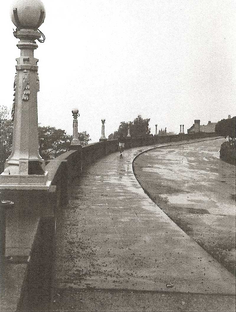
Willcox Wall, 1982
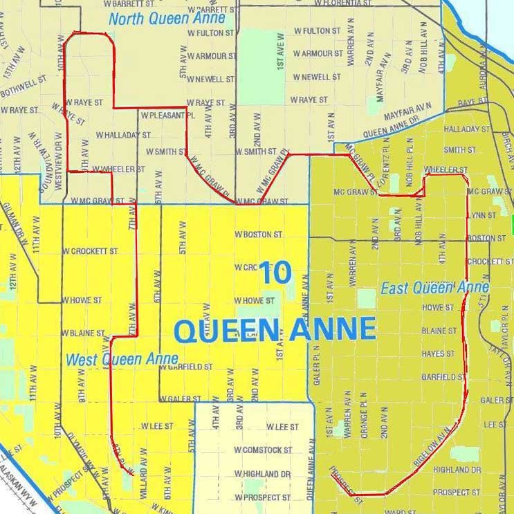
The scenic route called Queen Anne Boulevard winds around the crest of Queen Anne Hill nearly 3 ½ miles, providing grand views in all directions. Called a boulevard, the route follows various streets, including W Highland Drive, Bigelow Avenue N, and W Raye St.
The route includes several retaining walls, the best known being the Willcox Wall at Eighth Avenue W and W Highland Drive, built in 1909. Doris McClure Linkletter, whose family lived nearby on Eighth Avenue W, remembers going for walks as a child with her father up the long stairway to W Highland Drive. She, like many youngsters before and since, marveled at the wall, which appeared to be constructed of wood, for the surface had wood grain and knot holes, yet was as hard as the concrete sidewalk.
History of the Boulevard
Although it is incorrect to include our Queen Anne Boulevard among the boulevards identified by John Charles Olmsted in his 1903 plan for Seattle parks, it is equally incorrect to suggest that he and his firm, Olmsted Brothers, had no role in its creation. The facts and the name ultimately given to the route that circles the crest of Queen Anne Hill suggest another story.
John Charles Olmsted and his associate partner Percy Jones clearly evaluated the possibility of an ‘Olmsted boulevard’ on Queen Anne, but they excluded it from their 1903 report to the Board of Park Commissioners. As they evaluated boulevard possibilities in that summer of 1903, the Olmsted Brothers team took photographs of Queen Anne that tell amazing stories by themselves.
Enjoying success in their quest for thoroughfares, in 1906 the Queen Anne committee appeared before the Seattle Board of Park Commissioners proposing the development of a scenic route at the top of the hill to be called Queen Anne Boulevard. At this time John Clise was a member of the Parks Board and received support for the idea from other Queen Anne residents on the board, J.M. Frink and George Cotterill. In addition, John McGraw appeared before the Parks Board and spoke on behalf of the proposed route.
The Seattle Parks Board opposed the idea of the boulevard, since it was not a part of the 1903 Olmsted Plan for Seattle's boulevard and park system. The proposed route followed ordinary city streets, which did not meet the 150 foot minimum width called for by the Olmsted Plan to provide space for tree plantings and other amenities. The Parks Board finally agreed to the plan with the provision that the community pay some of the costs of development of the scenic route.
Constructed between 1911 and 1916, the boulevard was the only route by which commercial vehicles could reach certain sections of Queen Anne Hill. Queen Anne residents were happy with the boulevard for a time, but by the 1930s the complaints began pouring in and have not stopped since: “maturing trees are blocking the views; tree roots are buckling the side-walks; and the sewer lines are clogged by roots.” The Parks Dept. understood that many of the problems arose from the “cutting of corners” at the beginning and the failure to follow the standards established for boulevard throughout the city. For decades to come, Queen Anne Boulevard would be a headache for the city parks and engineering departments.
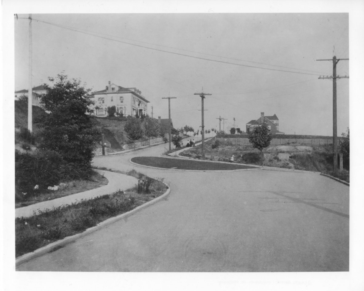
Highland Dr. triangle, 1903
The photograph of First Avenue North and Highland Drive reveals an elegantly laid out roadway with a delicate island forming the intersection, but there are only three houses in picture. All of them are located on Warren Avenue North, and all three are still standing. Today, you’d count at least 12 or 13 residences in the same view. The photograph is Dawson’s work.
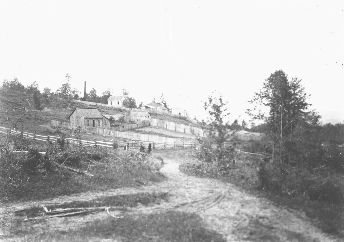
Look too at the May 1903 photograph of the west side of the hill taken from the corner of 10th West and West Lee, just a few blocks west and down the hill from the site of the boulevard. The rural feeling here, both in the path and the houses in the background, is astounding. Here the rough and ready quality of the buildings is unlike the ones in the few on Warren in the later picture, but the absence of buildings and trees is certainly comparable and almost surprising.
Courtesy National Park Service
“Queen Anne Scenic Driveway” is the name the Board of Park Commissioners used in Annual Reports for 1911, 1912 and 1913 to describe what we now call Queen Anne Boulevard. ‘Scenic Driveway’ is a striking name that announces the mission of the right of way following the crest of our hill. It was designed to show off the great views as one drove the route in an automobile. We’ve documented previously how the Olmsted Brothers omitted Queen Anne from their 1903 planning documents for parks, boulevards and playfields. We’ve also noted that foot-stamping by a committee of Queen Anners eventually got the road around the crest of Queen Anne in the city’s boulevard plans. As the Park Board’s annual report for 1911 documents, “approximately $188,000.00 has been assessed against their property with the understanding that the improvements of the driveway should be done by the Park Board.” The city’s other boulevards were all purchased with public funds. One might conclude that the reaction to the Olmsted exclusion actually got the Park Board to build Queen Anne’s route.
Here is how the Park Board’s 1913 report describes it:
Boulevard Map
Queen Anne Scenic Driveway: A series of city streets and condemned right-of-way nearly four miles in length, following in a general way the crest line of Queen Anne Hill, beginning at Second Avenue North and Prospect Street and terminating at Seventh Avenue West and Highland Drive. Several years ago the Park Board entered into an agreement with the property owners of the hill, whereby they were to acquire the right-of-way and pay the costs of same by local assessment, and the Board would improve and maintain the same as a boulevard (Italics added). The right-of-way has been acquired after several years of litigation. Plans for the improvement of the work, which will cost in excess of $300,000.00, were prepared and the engineering department for practical purposes in connection with the letting of contracts has divided the project into seven divisions….Three of the seven divisions were terribly short, probably because they required the most work. The seventh and most delayed division included only the McGraw Street bridge over the ‘gulch’ between Second and Third Avenues North. Division five ran only from 7th West to Galer and the division 6 from Galer to Highland Drive at Marshall Park. The southern portion of the Willcox wall runs through both division 5 and division 6.
The 1913 report mentions ‘retaining walls’ in Division 5, but the work in Division 6 is called a ‘viaduct.’ Viaducts are conventionally defined as ‘a long bridge-like structure, typically a series of arches, carrying a road or railroad across a valley or other low ground.’ Consequently, the report’s use of ‘viaduct’ leaves questions about the structural differences between the two sets of walls along 8th W.
Much as it would be convenient to overstate the distinction between a driveway and a boulevard, even the Park Board was ambivalent. In one place the 1913 Annual report calls out the Queen Anne Scenic Driveway. Elsewhere, it is called the Queen Anne Scenic Boulevard. Each annual reports divides the Park Board’s work falling into parks, playgrounds and boulevards where, as one might expect, they include the Queen Anne Scenic Driveway. By 1979 when it was designated a city landmark, there was no question. Queen Anne Boulevard is the name of our long landmark which unlike the Queen Anne Scenic Driveway of 1913 makes the full circle of the hill by including the portion from Highland at 8th Place West to Third North and Prospect where Bigelow begins.
For Further Reading
Queen Anne Boulevard, 12 sheets in Donald N. Sherwood's extensive notes about Seattle parks (compiled during Sherwood's 1955–1977 tenure as an engineer with the parks department). Includes detailed maps.
Read the entry about Queen Anne Boulevard at Wikipedia.
Read more about the Willcox Wall at HistoryLink.org.
Read the 1997 article Parks Battle Moves to Boulevards in the Daily Journal of Commerce.